How Much National Trust Or Open Access Land Is Near Railway Stations?
metadata
- keywords:
- published:
- updated:
- Atom Feed
Recently, I posted about How Much National Trust Or Open Access Land Is Nearby? The purpose of the previous blog post was to see if I could rank different locations by how much open land there was within a given radius, as I had realised that simply asking “how far away is some open land?” is a silly question.
This blog post is a generalisation of the previous one: I have downloaded the National Public Transport Access Node (NaPTAN) dataset and repeated the same survey for every single railway station in the UK. The new script is also available in How Much Land (HML). Unfortunately, the results for Scottish railway stations are pointless as the open land datasets do not extend north of the border.
§1 Railway Stations
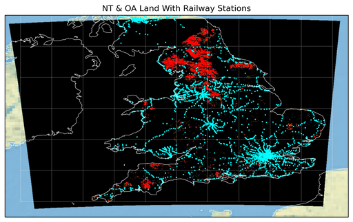
Below is a simple map showing all of the railway stations in the National Public Transport Access Node (NaPTAN) dataset that exist within the open land dataset (merged by How Much Land (HML)). I like the fact that the railway stations are so frequent that it is possible to infer the railway lines themselves.

§2 Open Land Within A 10km Radius
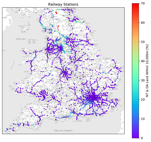
Looping over all of the railway stations it is possible to find out how much land is within 10km. The plot below shows the railway stations coloured according to this metric and the table below that shows the Top 10 (you can also download data as a CSV)

| Railway Station | Open Land Within 10km [%] |
|---|---|
| Garsdale Rail Station | 73.60 |
| Dent Rail Station | 71.57 |
| Alston Rail Station | 71.07 |
| Gilderdale | 70.78 |
| Slaggyford Rail Station | 69.77 |
| Kirkhaugh Rail Station | 69.33 |
| Lintley Rail Station | 68.49 |
| Ribblehead Rail Station | 68.47 |
| Stanhope Rail Station | 60.60 |
| Horton-in-Ribblesdale Rail Station | 55.09 |
§3 Open Land Within A 20km Radius
Looping over all of the railway stations it is possible to find out how much land is within 20km. The plot below shows the railway stations coloured according to this metric and the table below that shows the Top 10 (you can also download data as a CSV)

| Railway Station | Open Land Within 20km [%] |
|---|---|
| Garsdale Rail Station | 66.31 |
| Dent Rail Station | 60.29 |
| Alston Rail Station | 55.45 |
| Kirkby Stephen Rail Station | 54.50 |
| Ribblehead Rail Station | 54.17 |
| Windermere Rail Station | 53.53 |
| Horton-in-Ribblesdale Rail Station | 51.83 |
| Gilderdale | 51.78 |
| Kirkhaugh Rail Station | 49.07 |
| Haltwhistle Rail Station | 47.56 |
§4 Open Land Within A 30km Radius
Looping over all of the railway stations it is possible to find out how much land is within 30km. The plot below shows the railway stations coloured according to this metric and the table below that shows the Top 10 (you can also download data as a CSV)

| Railway Station | Open Land Within 30km [%] |
|---|---|
| Garsdale Rail Station | 52.98 |
| Kirkby Stephen Rail Station | 52.62 |
| Windermere Rail Station | 51.45 |
| Appleby Rail Station | 50.41 |
| Dent Rail Station | 50.25 |
| Staveley Rail Station | 48.06 |
| Ribblehead Rail Station | 47.68 |
| Horton-in-Ribblesdale Rail Station | 46.46 |
| Burneside (Cumbria) Rail Station | 43.83 |
| Bardon Mill Rail Station | 43.19 |
§5 Open Land Within A 40km Radius
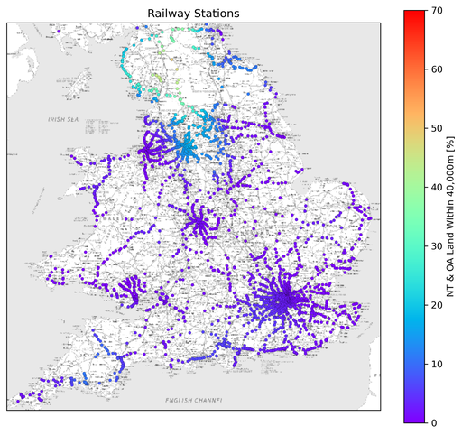
Looping over all of the railway stations it is possible to find out how much land is within 40km. The plot below shows the railway stations coloured according to this metric and the table below that shows the Top 10 (you can also download data as a CSV)

| Railway Station | Open Land Within 40km [%] |
|---|---|
| Appleby Rail Station | 49.56 |
| Kirkby Stephen Rail Station | 47.07 |
| Burneside (Cumbria) Rail Station | 44.84 |
| Staveley Rail Station | 44.75 |
| Garsdale Rail Station | 44.02 |
| Kendal Rail Station | 43.99 |
| Dent Rail Station | 43.45 |
| Oxenholme Lake District Rail Station | 43.14 |
| Oxenholme Railway Station | 43.14 |
| Penrith North Lakes Rail Station | 42.82 |
§6 Open Land Within A 50km Radius
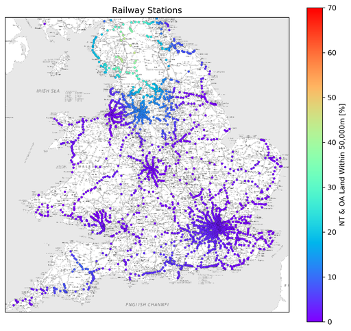
Looping over all of the railway stations it is possible to find out how much land is within 50km. The plot below shows the railway stations coloured according to this metric and the table below that shows the Top 10 (you can also download data as a CSV)

| Railway Station | Open Land Within 50km [%] |
|---|---|
| Kirkby Stephen Rail Station | 44.34 |
| Appleby Rail Station | 44.13 |
| Langwathby Rail Station | 43.35 |
| Kendal Rail Station | 43.22 |
| Burneside (Cumbria) Rail Station | 42.76 |
| Oxenholme Lake District Rail Station | 42.31 |
| Oxenholme Railway Station | 42.30 |
| Penrith North Lakes Rail Station | 42.29 |
| Lazonby | 40.64 |
| Lazonby Railway Station | 40.62 |
§7 Summary
To me, there are a few interesting observations to make from the above datasets.
- Very little of the large swathes of open land in England and Wales is directly accessible via train.
- If you want open land that is within 10km of a train station then the four large northern national parks are your best bet: The Yorkshire Dales; The Peak District; The North York Moors; and The Lake District (respectively).
- For the 10km survey, it is interesting that Surrey (with The South Downs) and Hampshire (with The New Forest) are actually worth considering too. This surprised me.
- However, when the survey is expanded out to 50km then the south of England becomes irrelevant and it is The Lake District and The Yorkshire Dales that dominate the map.
- Wales never enters in to a Top 10, regardless of survey radius. This also surprised me.
§8 Appendix
There is a tiny little companion script to generate downsized background images of open land for use in Python scripts.
1 2 3 4 5 6 7 8 9 10 11 12 13 14 15 16 17 18 19 20 21 22 23 24 25 26 27 28 29 30 31 32 33 34 35 36 37 38 39 40 41 42 43 44 45 46 47 48 49 50 51 52 |
|
checkout the “main” branch).